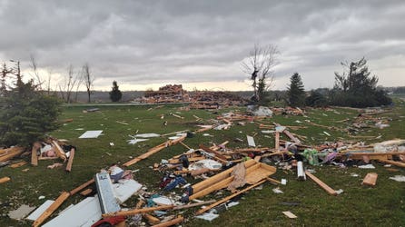
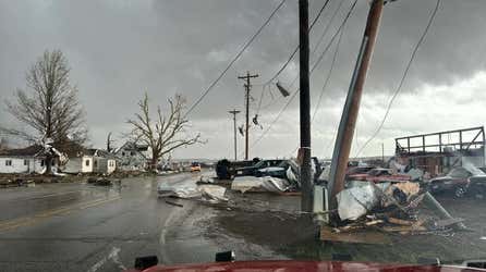
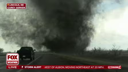
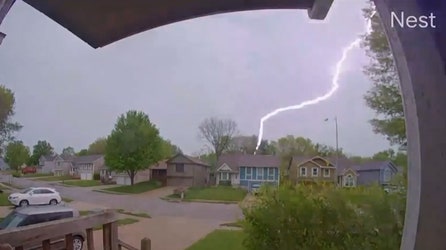
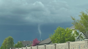
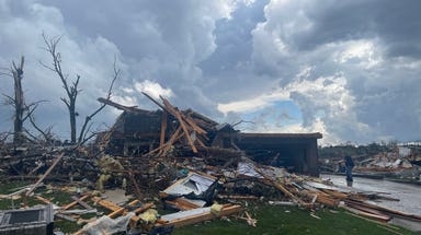
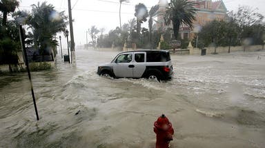
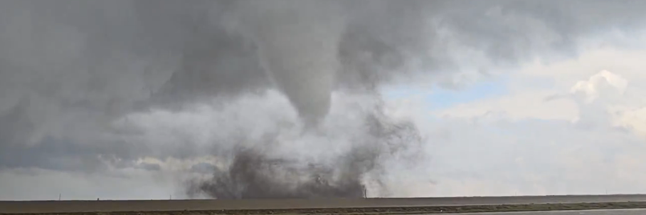
So with the month of October now over...folks in St. Louis are ready for the rain to be over too. 12.38" of rain fell in the month of October making it not only the wettest October on record, but the 4th wettest month ever! #mce_temp_url#
Enjoy the much needed break. Looks like things will be mostly dry and comfortable for the next week.
Last week I posted the story about Moscow's Mayor and his plan to keep Russia's capital snow-free this winter to minimize snow removal costs. Now meteorologists in Beijing are using the same method to increase snowfall to help with ongoing drought. Good idea? Or bad?
Here's my thoughts on this. I think this is a very complicated issue that is going to become a much bigger problem over the next few years. I grew up in Arizona where the Colorado River cuts through the Grand Canyon. There are ongoing legal battles about who has rights to that water. Arizona, Utah, Nevada and California all have legitimate needs. In the 1960s, a hydroelectric dam was built upstream from the Grand Canyon at Glen Canyon to create Lake Powell. I've spent a number of weeks water skiing on the lake and hiking around the area and it's a specatularly beautiful lake. The dam also destroyed what had been a spectacularly beautiful canyon. There are some other looming problems associated with Glen Canyon Dam #mce_temp_url# that will have to be addressed in the near future.
Damming, irrigation, canals, logging are all done with the best of intention and often with great benefits, but there are almost always negative consequences that follow. Cloud seeding adds a new element to man's tinkering with nature. Personally, I'm not comfortable with it. What are your thoughts?
This is the rainiest October on record in St Louis. 8.55" of rain breaks the old record set in 1919 of 8.52". So far, it's also the 3rd coldest October. Enjoy today, because the rain returns tomorrow and things look unsettled for most of the week....probably another 1-2" by weeks end. Thanks Marianne for the picture of your nice fall day. Take advantage!
I took this picture while walking home through Central Park yesterday. Our overnight temps don't get too cold so early in the season due to the our proximity to the ocean. The leaves change color a few weeks later here than those just about 20 miles inland! This time of year is absolute magic. Send me your fall pictures!
Did you hear the one about Moscow's Mayor? He wants a snow-free winter in his city and is pushing this controversial project. I'm not a fan of the idea.
Just a quick welcome to my blog, which went live today. I'm looking forward to this!
Also, since Janice Dean has so many and such loyal followers she's getting her own URL! So if you're looking for her, bookmark this new address. http://janicedean.blogs.foxnews.com/ she'll be keeping up her blog as always right there!
I can't remember a more bizarre October. When this month started, the northeast was on it's nicest stretch of weather all summer. California was in severe drought and facing a dangerous fire season. South Florida was beginning a stretch of 13 days of temperatures above 90 degrees.
Suddenly two early season nor'easters hit the northeast bringing the earliest snowfall on record for the mountains of Pennsylvania and New York. A cold front drives all the way to Cuba and the Yucatan peninsula of Mexico and drops Florida's temps from record highs, to record lows...a drop of around 25 degrees. And the west coast gets pummeled by an early season storm dumping up to 10" of rain in parts of central California and winds of over 60 mph in the bay area. This system was actually remnants of Typhoon Melor which hit Japan last week!
This week was certainly a game changer. Much of northern California declared an end to Fire Season. This means burn bans have been lifted in many National Forests and BLM areas. The northeast went straight to winter. And Autumn finally arrived in Florida.
Spring and Fall are the two wacky seasons in weather. This fall is certainly off to a strong start.
Japan is being battered by Typhoon Melor, the worst typhoon to strike the island nation in a decade. (A typhoon is the same thing as a hurricane...they call it a typhoon is the western Pacific and Indian Oceans.)
Melor is interesting for a couple of reasons. As of three days ago, Typhoon Melor was a Super Typhoon and the equivalent of a Category 5 hurricane with sustained winds of 160 mph. It's making landfall with winds around 90-95 mph, but the storm surge and waves will be more damaging than a 90 mph storm due to it's prior intensity. Also, the storm will impact pretty much the entire main island of Honshu, which is home to over 100 million people. Tokyo will be on the bad side of Melor. Fortunately, Melor is booking to the northeast at about 29 mph, so that will keep rainfall totals down and limit widespread flooding.
Japan is no stranger to Typhoons having last been struck two years ago.
Welcome to my Weather Blog! I've been spending way too much time trying to decide in which direction to take this blog. I'm still fairly undecided so I figure I should just jump in and figure it out as I go. But here's a few of my ideas of what you can expect... (aside from lots of elipses)
1. I'll talk about fun/crazy/dangerous/peculiar weather phenomena, from a scientific angle and the human angle.
2. I'm fascinated by all kinds of weather, not just the violent stuff we tend to focus on in Cable TV news. And I love geography, travel and people, so I'll probably bring in world weather stories.
3. I really want a lot of info flowing back to me..like your weather stories, and pictures and video. I'll put your pictures on this blog in a really cool way, and every chance I get I'll throw your pictures into one of my TV forecasts. It will be really cool when we are breaking weather stories on TV because you are sending me pictures via Twitter @rickreichmuth or on the link on this page.
Enough of that. So check out these pictures out of Sydney, Australia from yesterday? They got hit by one of their worst dust storm in decades. Dust storms aren't all that uncommon but they don't typically make it all the way to the eastern coastal areas. Australia is a typically dry continent and suffers from periodic drought, but some areas in the southeast are under their worst drought on record. Add in a big 60 mph wind storm and this is what can happen.
Eastern Australia's drought will likely worsen over the next 6 months as they are dramatically impacted by El Niño ...and we are entering into a strong El Niño cycle.