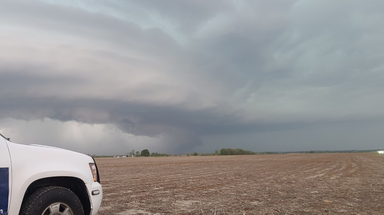
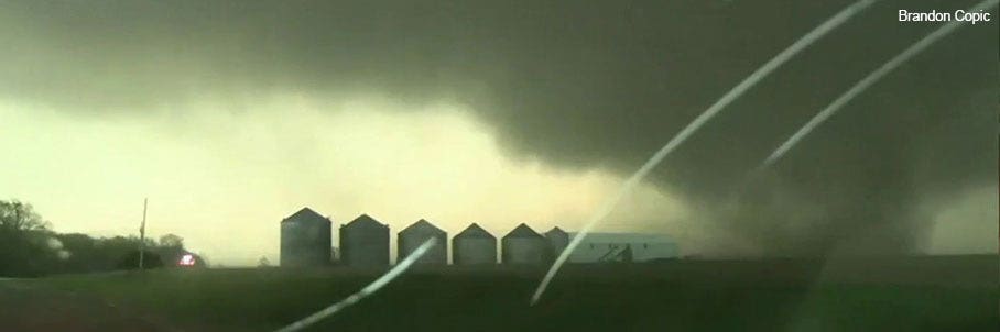
Fox News - Fair & Balanced

Wednesday, April 7, 2010 as of 11:14 AM ET

Search Site

FOX News Weather Blog
  • Prayers for Boston

    Janice Dean | Meteorologist

    Hi everyone…

    The tragic events in Boston are top of mind for all Americans today.  The stories about the little ones that were harmed or killed yesterday are the ones that haunt me.  I hugged my boys again tightly last night and prayed that they never have to go through such devastation in their lifetimes.  We do the best we can to protect our children but sometimes horrific events take the lives of innocent victims.  The only thing I can come up with is God needed more little angels in heaven yesterday. 

    Seeing random acts of kindness has helped.  The brave firefighters, policemen and women, EMT workers that run towards the danger to save others.  The runners who crossed the finish line and kept going until they got to a hospital to give blood.  Strangers taking off clothes to help bandage up injured.  Boston residents who have opened up their homes to let people rest or sleep while they wait to hear from loved ones.  Hospital staff who have been up all night to take of the sick and injured.  

    And it all began on a beautiful spring day in one of our country’s most beloved cities.  The sky was blue, the air was crisp.  A day to celebrate in Boston.  Patriots Day.  One of the biggest and best Marathons in the world where families gather to cheer on their families and friends.   A little boy was waiting for his Daddy to cross the finish line yesterday afternoon.   I’m sure he couldn’t wait to see his father’s face in the crowd…just like my precious boys run to the door when their dad comes home from work.  It breaks my heart when I think of the bombs going off.  That little boy waiting to give his dad a hug.  He never had a chance.   His face haunts my thoughts today.  I pray for his family.  I pray for our country.  I pray for our children.  I pray for peace.  I pray for Boston.

    JD

  • More snow and severe weather this week

    Janice Dean | Meteorologist

    Hello everyone!

    Happy weekend to you all….

    We saw some pretty extreme weather last week with record breaking April snow to hundreds of reports of severe weather including over a dozen tornadoes that did tremendous damage, and killed 3 people. 

    We have a similar set up this week with more crazy snow and the threat for strong to severe storms across the Plains.

    A new storm pushing across the Rockies will move into the Central U.S. starting tomorrow through Thursday.  Here’s a look at the snow threat:

    Temperatures will be 5-25 degrees below average as this new storm pushes into the Northern Plains and Upper Midwest

    Winter weather watches and warnings are up:

    Meanwhile, the severe storms could start up tomorrow and last through Thursday!

    On a nicer note, we’ve got wonderful weather here in the Northeast this week including D.C. where the cherry blossoms are in full bloom!  Gorgeous!

    While in Denver, they need to be shovel-ready again for more snow!

    How’s that for extremes?   Hope you all have a safe and wonderful rest of your weekend!

    JD

  • SEVERE WEATHER THREAT THROUGH THURSDAY

    Janice Dean | Meteorologist

    Hi everyone!

    Big weather happening today through Thursday.  Here are the details:

    A strong system over the Plains will bring heavy snow, wind and severe storms to the nation’s midsection today.  Blizzard conditions are possible along the Front Range in Colorado, where gusty winds up to 50mph will combine with heavy snow to create drifting and white-out conditions through this evening.  

    1-2 feet of total snow accumulation is likely across eastern Colorado and Wyoming through tomorrow.  Winter Storm Warnings extend through the Northern Plains and into Minnesota as a wintry mix and 4-8″ of snow is likely across the region through Wednesday.  

    Meanwhile,  severe storms are a concern along the eastern and southern sides of the system.  Strong straight-line winds, hail and tornadoes are expected from the Midwest and Central Plains to Central Texas, including Kansas City, Oklahoma City and Dallas.

    The threat will shift eastward Wednesday, bringing damaging winds, large hail and tornadoes to the Mississippi Valley and Ohio Valley.  

     Much warmer temperatures continue building across the Mid-Atlantic and Northeast today and tomorrow, where afternoon highs will be 15-30 degrees above average.

    Temperatures will return closer to seasonal averages by the end of the week.

    I hope you’ll all keep an ear to the local forecasts expecially if you live in any of the “yellow” shaded areas on the severe map.

    And here in the Northeast, I’m getting thanked for springtime/summertime temperatures (FINALLY!)…but by the weekend we’re back to more “seasonal” averages…

    Have a great day everyone!  Talk to you on the weekend.

    JD

  • First potential severe weather outbreak of 2013

    Janice Dean | Meteorologist

    Hello everyone!

    Hope you’re having a great weekend.  Wanted to give you all an early heads up that we are about to get very active in terms of severe weather this week. 

    We’re watching a system that will blast out of the Rockies and will bring the potential for life-threatening weather across the Plains and the Mississippi River Valley starting Monday and lasting through Wednesday.  This could be our worst outbreak since last May.  Here are the areas we are monitoring closely:

    As you can see, it’s been a quiet start to the year in terms of tornado numbers, but that could change:

    And this is typically the “bullseye” where we see the most severe storms during the month of April:

    Meanwhile, the eastern half of the country is going to feel a nice Spring warm up this week (look at these 80 degree temps!)

    However, we’re still feeling below normal temperatures for the Upper Midwest with rain and snow for the region.   This next big storm could bring huge snowfall numbers over the Plains and Midwest:

    Also, weather was in the news this week as the National Weather Service has changed their “warning” system in the wake of Hurricane Sandy.  This is big news because many forecasters believe (including myself) that because hurricane warnings/watches were never issued for the Northeast during the height of Sandy, there was some confusion from the public and officials about just how serious this storm was going to be.   If you were affected by Sandy, or live in an area that could be affected by hurricanes, this is worth a read: 

    http://www.washingtonpost.com/blogs/capital-weather-gang/wp/2013/04/04/weather-service-changes-criteria-for-hurricane-warnings-after-sandy-criticism/

    That’s it for now.  I’ll be sure and keep you updated with the latest in severe weather news as we get closer to the event on Monday.

    Be safe, and have a great weekend.

    JD

  • Fun on the Green Screen!

    Janice Dean | Meteorologist

    Hi everyone!

    Well, I guess the OPEN BLOGS that I timed to go up while I was away failed bigtime.  UGH.  Sorry about that.  I hope you all had a great Easter.  I went to my Mom’s retirement lunch back home last week and spent a few days with her.  She is now staying with us for the next few weeks here in New York to ease into her new permanent vacation!  The kids are having a great time with Grandma.

    Weather has been relatively quiet, however we’re about to get into a “Springtime” active pattern meaning the set up for the next couple of weeks will be condusive to severe weather including tornadoes.  

    Here in the Northeast, the Midatlantick  and back into the Great Lakes and Upper Midwest we’re feeling pretty chilly temperatures for the beginning of April.  Thankfully, this is short-lived, and by the weekend we’ll have a “spring” in our step.

    That’s about it for now, but I thought I would post a few pics of my boys when they came to visit me a few months ago in my little Green Screen office!  ;)   My little weather-interns!

    Have a great week, everyone!

    JD

  • HELLO...SPRING??? CAN YOU HEAR US?

    Janice Dean | Meteorologist

    Hi everyone

    Yes, another winter storm has dumped impressive snow totals over many states stretching from Colorado to Maryland!  Look at some of these numbers!

    We’re still going to see snow showers through the day today, but by tonight the worst of the storm will be off shore…

    And while, it’s cold for many of us, there is a WARM UP on the way by the end of the week!

    New York will warm up to “seasonal averages” with partly cloudy skies into the Easter weekend…

    And Colorado will also be enjoying near/above average temperatures by the weekend:

    Finally a little good news!  Spring is just around the corner…I promise!  And sooner than you know it we’ll be complaining about the heat.

    In other news, I’m going to be off until next Tuesday.   Taking a little long Easter holiday to spend with my family at home.  I’ve scheduled a few OPEN BLOGS while I’m away.  Have a safe and wonderful long weekend.  Talk to you all next week!

    JD

  • ANOTHER BIG WINTER STORM AFFECTS MILLIONS

    Janice Dean | Meteorologist

    So much for spring!  We have another massive winter storm that is going to bring a wide swath of 6-12 inches of snow from Colorado, through Kansas and Nebraska. 

    The system is now moving into Missouri, Illinois and then across the Ohio Valley Sunday. 

    On the warm side of this storm, severe storms are possible along the Gulf Coast from Texas to Florida including strong winds, large hail and isolated tornadoes. 

    Tomorrow night into Monday, the storm will push across the Midatlantic and Northeast with the potential for heavy snow for all of the big cities across the I-95 corridor! 

    This is obviously something we’re going to keep a close eye on in the next 48 hours as it will affect millions of people trying to get to work on Monday!

    Hope you’re all having a good weekend.  Keep those prayers coming for our friend Don.

    JD

  • WANTED: GROUNDHOG!

    Janice Dean | Meteorologist

    Hi everyone.

    Another cold day for the Northern half of the country.  Our pals to the South are enjoying springtime/summertime heat! We’ve got the potential for another winter storm this weekend which we’ll of course have all the details on over the next few days.

    Meanwhile, I thought you all would find this humorous!  Punxsutawney Phil is in some big trouble in Ohio!  Check it out HERE

    In the meantime, prayers to our friend Don who A.J says is in the hospital.  We’re all thinking of you buddy.  Stay strong.

    I’ll have another blog update on Saturday.

    JD

  • OPEN BLOG!

    Janice Dean | Meteorologist

    Hi everyone

    Ugh.  Another winter storm.  I have to admit, I’m a little depressed by this!

    The only thing that makes me happy about snow is these two pictures that were taken much earlier this winter when winter is supposed to happen:


    But, thankfully, not all of us are still into the deep freeze.   The southern half of the country is feeling springtime (even summertime) weather!  Us folks across the North are feeling cold, wet and snowy conditions again this week.

    I don’t even feel like blogging about it!  LOL!

    So please use this space to talk about fun stuff! :)

    JD

  • St. Patrick's Day weekend!

    Janice Dean | Meteorologist

    Good morning everyone!  Happy Friday!

    Our last official “weekend” of winter according to the Calendar.  Hopefully Mother Nature is listening!  It’s warming up across a big chunk of the country except the Midwest, Great Lakes and Northeast!

    Today we’re watching a system across the Midwest that will bring a few inches of snow from the Dakotas through Wisconsin today.  Some areas could see a wintry mix where temperatures hover around the freezing mark.  Some light rain or snow will spread across the Northeast on Saturday but much of the region will be generally dry today.  We are going to watch a new storm push across the Midwest and Northeast early next week bringing the potential for heavy rain, wind and snow:

    Across the West, light rain and or snow across the Northwest otherwise dry and warm.  The Southwest continues to be hot with record highs possible for Phoenix and Tuscon!

    And this weekend we celebrate St. Patrick’s Day!  Here’s a couple of big cities that will be seeing green:

    Hope you’re all doing well.  Have a wonderful weekend!

    JD

about this blog

  • Cold fronts, snowstorms, hurricanes, and sunshine. Fox News Channel meteorologist Janice Dean blogs about it all here. You can also follow Janice on Twitter.